Hurricane watching and playing with GRIB files
Posted By RichC on August 30, 2010
 As the tropical activity heats up in the Atlantic, I wanted to play a little more with raw data to see exactly what kind of projections are concluded. For those not in the bluewater sailing or weather watching world, the data is downloaded and run in GRIB file readers. I’m using UGRIB and imported the data about 17:00 EST on Monday.
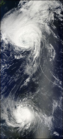
Currently the storm centers of Danielle and Earl are both spinning around in the Atlantic Ocean and they were impressively captured by NASA’s Terra satellite (be sure to click for larger files). Both of these storms are expected to impact land with Earl seemingly the biggest threat to the US east coast later this week. Below is a short video projecting the path.
Danielle started causing problems for U.S. east coast residents this past weekend with large waves and dangerous surf conditions and reports indicated that more than 100 people were rescued from dangerous currents in beaches from Maryland to New Jersey. According to reports, “large waves and dangerous surf conditions are diminishing around Bermuda today, and will gradually subside along the U.S. east coast over the next couple of days. Waves near 10 feet however are expected to develop this afternoon along parts of Newfoundland, Canada as Danielle tracks northward. Danielle’s maximum sustained winds were near 75 mph, and it is expected to weaken in the next 48 hours and become extratropical.
[flv:hurricanewatch100829.flv 490 355]
Earl is now consider a “major hurricane (Category 3)” and has maximum sustained winds near 120 mph. Earl’s center was about 95 miles east-northeast of St. Thomas and 165 miles east of San Juan, Puerto Rico. The National Hurricane Center stated that "Hurricane conditions will be spreading across the northern Virgin Islands during the next few hours. Tropical storm conditions will spread over portions of Puerto Rico this afternoon with Hurricane conditions possible this evening and tonight. Storm surge will raise water levels by as much as 3 to 5 feet above ground level primarily near the coast in areas of onshore wind within the hurricane warning area…and 1 to 3 feet in the tropical storm warning area. The surge will be accompanied by large and dangerous battering waves. Earl is expected to produce total rainfall accumulations of 4 to 8 inches over the Leeward Islands, The Virgin Islands and Puerto Rico with possible isolated maximum amounts of 12 inches especially over higher elevations."
Comments