Well prepared cruising sailor shares his story
Posted By RichC on January 26, 2010
Wayne Meretsky shares the “Loss of Moonduster“
We arrived in Savusavu, Fiji, on Monday, November 23, after a fairly uneventful 3-day passage from Tonga. Our goal was to spend a month cruising the western Yasawa Islands before leaving from Lautoka around Christmas to arrive in New Zealand early in the New Year.
After a week in Savusavu sampling the amazing curries and reprovisioning, we headed west along the southern coast of Vanua Levu and then off to Yadua Island before making the 60 mile leap to the Yasawa Islands.
During these early island hopping day sails, we experienced the navigational challenges that are the source of so many cruiser conversations about Fiji – reefs often appear just a few boat lengths ahead in areas where the charts show nothing. It’s not that the charts show deep water – rather the charts simply have vast areas surrounded by boundaries stating that the waters have never been surveyed. In some areas, aerial photographs are used to help determine the location of various islands, but even those locations are not GPS corrected. Discolored areas of water as shown in those photographs are shown on the charts as reefs, but many reefs remain undetected in the absence of a high-quality survey of the ocean floor.
It’s this aspect of Fiji’s waters that make cruising a tedious proposition. One can only navigate during daylight hours and then only with the sun well above the horizon and behind you as you pick your way along. In the two seasons I’d been in the South Pacific with Moonduster, I knew of four boats lost on Fiji’s uncharted reefs.
Our first stop in the Yasawa Islands was Sawa-i-Lau, where we toured the splendid caves. Next we headed south and enjoyed Nanuya Resort at Blue Lagoon. From there we stayed a night at Korovou and visited the Eco Tour Resort before heading south again to check out the manta rays that congregate in a pass near Drawaqa Island. It was there that it all began to go terribly wrong.
The beginning of the end
Manta Ray Pass is a narrow lead between two islands with depths of just 16 feet. The manta rays weren’t in residence, having left for the summer months. The anchorage is an open roadstead and very exposed to the north, west and south. With the strong easterlies, it was workable but the trades would occasionally blast over the cliffs and drive the boat first north and then south, leaving a track on the GPS that looked like a child’s scribbling. Somewhat more troublesome was a swell that wrapped around into the pass and caused the boat to roll and, in turn, Neria’s stomach to churn.
In the early afternoon, I downloaded our regular what’s-up-with-the-weather GriB and the text-based summary from Fiji’s Nadi Met Service. The GriB showed a slight, shallow bend in an isobar about 100nm north of our position. The Nadi summary mentioned a low that was forming to the north but nothing else of note – it included the standard “Warnings – Nil”.
We decided to head into the resort for dinner – mostly to get off the boat and see if that would allow Neria a break from the slight nausea that had been plaguing her all afternoon. Stepping ashore was a magical antidote. The resort at Manta Ray Pass was filled with the usual mix of young backpackers from around the world. We spoke mostly with a young couple from Germany who mentioned how wonderful it must for us to live such a “carefree” life. Neria and I exchanged glances and tried to convey how cruising might be many things but that it was rarely carefree.
The dinghy ride back to the boat was a little wet and wooly. A good sized standing wave had formed in the pass – the effect of wind against current. Even with the outboard simply idling and both of us standing in the inflatable, we wound up wet from head to toe.
Back aboard, we turned in and both had a reasonable night’s sleep interrupted by a few blasts of wind and an occasional beep from the GPS-based anchor alarm as the boat ventured a little further north or south than the radius I’d programmed on our arrival. With each of those beeps, I’d climb out of bed, take a quick survey of the situation both on the GPS and visually, concluding that we were still hooked up tight and that there was no reason to do anything other than reset the alarm and crawl back into bed.
On Sunday morning, December 13, we arose, as usual, just a bit after dawn and while Neria pulled breakfast together, I pulled in the morning’s GriB and emails. Of interest was a low, clearly identified on the GriB where the previous afternoon there had only been a slight hook in an isobar. In addition, the Nadi forecast made note of the low and had a warning for the possible formation of a tropical depression with winds in the 20-30 knot range.
By 9:00 a.m. we had the hook up and were on our way to Waya Island. Octopus Resort is located at Likuliku Bay on Waya’s west coast and had been on our itinerary since Linda, the masseuse at Blue Lagoon had recommended it during our stay. It made good sense as a hide out from the forecast weather because as the depression came closer, the winds would clock from the prevailing southeast trades to northerlies and then northeasterlies. Then, as the depression move past, we could easily move the 3.5 nm to Waya’s northern Nalauwaki Bay for the forecast southerlies and westerlies.
Also at Manta Ray Pass that morning was the crewed charter boat Star of the Pacific. We hailed them on the VHF radio as they departed Manta Ray as they represented an opportunity to get some local information on the anchorages at Waya and our general plan for the approaching weather. Unfortunately, they never responded on the radio.
Leaving Manta Ray, we motored around the corner and left to the west of the pass, between the islands of Nanuya Balavu and Naukacuvu. In this deep, narrow lead, we met head winds of just over 30 knots combined with a good bit of northerly setting current. The combination of wind and tide slowed our progress to about 1 knot over the bottom and, under power, we made a few tacks back and forth across the channel taking about 1 hour to get through. Not far ahead, the Star of the Pacific was also laboring through the pass but once clear, began punching through the chop on their way towards Vuda Point where we would see them again much, much later.
As soon as we cleared the pass, the wind that had previously been funneled between the islands both eased a bit and clocked well to the east – a sure sign that the depression was disrupting the reinforced south easterly trades that we’d been experiencing since leaving the coast of Vanua Levu.
We rounded the southern tip of Narara Island and headed into Nalauwaki Bay. Our goal was twofold. First, we thought there might be a chance that the high headlands on the eastern side of the bay could provide sufficient protection from the north easterlies. Failing that, we wanted to collect a GPS track of the bay and familiarize ourselves with the anchorages that were described in our cruising guides to that should we have to enter the bay and anchor at night we’d have a bit more knowledge of where we should go and what we’d find.
The pass through Nalauwaki proved disappointing. The headlands were impressively steep and beautiful to look at, but they were steep-to and not only were there no anchorages, but the winds were blasting down onto the surface of the bay and driving great clouds of spray across the bay. We continued on around, locating both anchorages and the various reefs within the bay. Then we headed north and then west and south and into Likuliku Bay.
Likuliku Bay is typical of anchorages throughout the Yasawa Islands. There are a few centrally located hazards and a long fringing white sand beach. Octopus Resort is located a bit south of the middle of the bay and the only other sign of habitation is a small compound at the northern extreme just where the sand gives way to a rocky outcropping that forms the north western point of the bay.
The bay was flat and the winds were in the mid teens with occasional gusts to the low twenties, conditions to which we were well accustomed. We anchored in 35 feet of water just north of the resort in the place that the cruising guides recommend. We set our primary anchor, a 55 pound delta, firmly on 200 feet of chain and set up the 5/8” nylon three-strand snubber. Moonduster’s foredeck cleats are set well back from the bow, just inches from the forward end of the foredeck hatch – nearly 12 feet back from the bow roller. This means that with the chain hook just in the water, there’s about 20 feet of line to absorb and dampen any shock loading.
From the boat, we could see guests at the resort lounging on the beach, a few paddling about in the water and many more in the beach front restaurant and bar. I called the resort of the VHF to see if they had any further weather information and whether they’d be willing to run us in for dinner in one of their boats.
The exchange was pretty simple. They’d be happy to collect us for lunch or an after lunch drink, but they planned to pull their boats for the evening because the forecast included westerlies and pulling the boats was their standard precaution for any wind in excess of about 15 knots from the west.
Neria and I decided to forego the shore trip and had a light snack and then settled in for a nap. At around 3:00 p.m., I awoke to the sound of an outboard motor and the hearty sound of a Fijian shouting the customary greeting of “Bula!”
I popped up the companion way and found myself looking at a youngish man driving one of the resort’s aluminum skiffs equipped with a 40HP outboard. In a concerned and agitated manner, he blurted out, somewhat prophetically, “Whatcha doing man, there’s a hurricane tonight and you need to go to the marina or you’ll be on the beach in the morning.”
I was taken aback and my stomach tightened in a nasty knot. I asked, “What marina?” knowing full well that the only marina about was the Vuda Point Marina located to the east south east and about 35 nm away. Given the forecast winds, that would mean sailing upwind, at night through reef strewn waters with charts that aren’t GPS corrected and through areas that have never been fully surveyed.
I thanked the boat man for the message and went back down below, firing up the PC, the SSB and calling the resort on the VHF all at the same time. In short order, Nick, the resort owner clarified the situation. There was no hurricane coming, but the forecast had been updated to a Category 1 Tropical Cyclone that would pass north of the Yasawa Islands before moving off to the east. Maximum winds would be 40 knot north easterlies near the eye of the cyclone and would occur the following morning just before mid day after which the winds would abate as they shifted to the south and then west.
I asked if I could get a lift into the beach so that I could check the full forecast online and also call Nadi’s Cyclone forecasting center to get additional information. Nick graciously agreed to send his boat back out but added that I’d have to be quick because they were already pulling one other boat and would be sending two others to Yalobi bay at the southern end of Waya and pulling the last boat soon.
During all this discussion, I’d pulled down yet another GriB and took a quick look at the latest model. With a frame every three hours for two full days, it took a few minutes to extract a synopsis, but the data said that winds in our location would peak at 30 knots from the NE and that the storm would pass our location around mid-day on Monday – in other words, the best information available hadn’t changed significantly and the overwhelming sense was that our plan remained both well-informed and completely viable. So, with a quick hug for Neria, I jumped in the launch and dashed ashore.
Once on the beach, my stomach quickly relaxed. Although there was a bit of commotion associated with pulling the heavy dive boat out of the water, the rest of the scene was just like that at any resort in Fiji. Resort guests were lounging by the pool, sipping beer in the bar and paired up on the beach enjoying the sun. As I made my way to the office, there were staff providing towels and mixing drinks. A short line of people were waiting to use the phone or the internet. No one was concerned in any way about the weather including the resort’s jovial owner, Nick, who showed me the latest information he had.
I quickly realized that Nick was getting the same forecasts from Nadi that I was downloading via Saildocs and decided there was no point in rereading what I’d already poured through. Instead, I got online and tracked down the number of Nadi’s Tropical Cyclone Center, borrowed a phone and called Nadi.
It took a couple of transfers, one of which was dropped, but after redialing I was quickly connected to someone in the TCC. They were courteous and pleasant, but could do little more than reiterate the contents of the text-based forecast. The storm would pass north of the Yasawa Islands before heading east through the waters that separate Viti Levi and Vanua Levu. Winds would peak at 40 knots. The storm center would pass around mid-day on Monday.
By the time I was off the phone, Nick let me know that I’d have to leave shortly as they were finished pulling the dive boat and the launch would be coming out soon. He suggested that perhaps we should move Moonduster to Yalobi, Waya’s southern bay as it would offer better protection from the north easterlies. I countered that I was concerned about being down south when the winds went south and that my plan was to relocate to the north in the southerlies and ride out the second half of the storm in Nalauwaki.
Nick shrugged a bit and conceded that the southern bay offered no protection from southerly winds. With that, I thanked him for everything and headed back to the beach.
In short order, the launch crew of two, me and two other boat men were in the launch and headed out onto Likuliku bay. We dropped the two boat men on the resort’s two other boats as they were soon to depart and head south. Then, they dropped me at Moonduster.
Back aboard, Neria and I reviewed everything. We reviewed the various anchorages, the Nadi analysis and the GriB data. We looked carefully at running to either Vuda Point or Musket Cove but just couldn’t get past the dangers of sailing at night, upwind into 30+ knots of wind across unsurveyed, reef-strewn. Convinced we had the best plan, we spent a bit of time tidying up the boat, doing dishes and stowing those few odds and ends that always seem to be lying about. With that behind us, we settled in for what was likely to be a restless night.
Sunday Evening – The Gathering Storm
Many say that sailing is hours of boredom interrupted by moments of shear terror. So, too, is waiting for a storm to come. The winds continued to slowly build throughout the late afternoon.
Around 1700, I sent a note to Neria’s dad, Neil, asking if he might get online and check the Nadi Met Service web site and figure out how we could subscribe to their Cyclone Bulletins. We knew how to get the bulletins via Saildocs, but that process requires making a request, waiting a few minutes and then receiving the reply. If it were possible to subscribe, the bulletins would just show up in our inbox and save a lot of tedious sailmail work, especially because SSB radio propagation hadn’t been great for the last few days.
Around 1900, we had a light pasta dinner, taking care to not make much of a mess and to quickly clean up and stow everything in the galley. As darkness fell, we checked the GPS and found that sunrise would be at 0630 the following morning as we made note that it would probably begin to get light between 0530 and 0600. We also came to realize that while not a new moon, the moon was such a tiny sliver that there would be no light at all for the evening.
I programmed the GPS with the approximate coordinates of our anchor and programmed it to navigate towards that position. This gave us a “Distance to Destination” that would indicate how far we were from the place we dropped the hook. Knowing the length of the rode, this let us monitor whether the anchor was dragging with pretty good precision.
We settled into a fairly simple routine. Neither of us was in much of a mood to sleep and it was a bit bumpy and a bit noisy, anyway. Instead, we chatted, snacked and tried to get some rest. We used the kitchen timers that I’d used for thousands of solo miles to maintain a regular watch at one hour intervals.
Each hour we’d record a number of things from various instruments on the boat. The written record allowed us to notice trends and forced us to check everything we thought was note worthy. The list included wind speed, true wind direction, barometric pressure, distance from the anchor measured with the GPS, distance from the shore measured with the radar and water depth.
Neil responded around 2130 with a copy of the various bulletins but was unable to figure out how to subscribe. One of the documents he forwarded, which we had not seen previously, included a request from the Fiji Met Service for vessels to forward wind speed & direction information and also barometric pressure to them via Telex, Navtex or e-mail. Our first e-mail to them, at 2220, reported 30 knot winds with regular gusts to 40 and occasional gusts to 45 knots from 100 degrees, true and a barometric pressure trend that was down 2.5millibars in the last 12 hours.
It’s always amazing to me how well one adapts. When anchored in a calm location, a 20-knot gust from a passing squall sounds like a freight train. After a few hours of 30 knots, a 20-knot spell sounds wonderfully silent but a 45-knot gust raises all sorts of hackles.
The wind was remarkably variable in terms of speed throughout the night. While the trend continued to increase, there were often periods of 5-15 minutes where the wind dropped to the mid teens and, occasionally, as low as 5-10 knots. Each time one of these lulls would begin, the anchor rode would settle under its own weight and slowly move the boat back towards the anchor, about sixty to seventy feet.
With the rode hanging straight down, the boat’s behavior was somewhat alarming when the wind would, again, begin to build. The bow would fall well off the wind – 45, 50, even 60 degrees – and the GPS speed would climb quickly to ½, ¾ or even a full knot. Then, with the weight of the chain acting as a brake, the boat would decelerate, turn and face the anchor and slowly settle into position for the coming onslaught.
Because of all this motion, I went on deck a few times to ease the snubber a few inches to alleviate the affects of chafe. I made sure to check the line for signs of abrasion but I never saw more than a slight fuzziness.
The hours from midnight through dawn were fairly uneventful and passed in a slight daze. The wind continued to oscillate in both speed and direction – we started to develop a concern that the terrain on Waya Island might prevent us from knowing the wind’s true direction because the gusts coming down from the cliffs, bluffs and peaks moved through a fairly wide range (060 to 125, True) without any discernable pattern. We each took turns reading, attempting to nap and always recording and evaluating conditions on 30-minute intervals. We continued to download GriB data and Nadi’s forecasts as they became available and poured over them trying to glean anything that might affect our situation.
The 0430 weather updates hadn’t changed much. The Nadi storm track forecast was slowly converging with the GriB predictions. Where Nadi had previously predicted the storm passing a bit further north and moving away nearly due east, they now showed it passing nearly directly over us and moving away to the southeast. But all predictions for wind strength continued to show average winds peaking at 40 knots.
The mood onboard was somber. Both of us continued to be surprised at the rapidity with which the storm had formed and how little notice we had had. We reevaluated the decisions we’d made but continued to come back to Likuliku Bay as having the best chances of saving the boat without unnecessarily risking our lives. There were lots of hugs, some tears and an occasional feeling of helplessness. We spent time talking about contingencies and we assembled the EPIRBs, personal strobes and other safety gear that’s usually stowed while coastal cruising.
For the past few months since we arrived in Tonga, both Neria and I had been rising when the sky began to lighten each morning. Sunrise and sunset come quickly in the tropics but we’d always had 30 minutes of light before the GPS-predicted sunrise. On the morning of the 14th, the sky was still dark 15 minutes after the GPS prediction had come and gone. When first light slowly peeled back the cover of darkness, it revealed thick, black clouds low in the sky obscuring the peaks of Waya Island. Despite their foreboding appearance, daylight brought with it an undeniable relief and we were fairly confident that by sunset the worst would be over, for better or worse.
Throughout the night, the winds had built and diminished without much rhyme or reason. A 20-knot lull might be interrupted by a 40-knot gust or it might simply build to 35. That trend continued in the early daylight hours, and with it, the boat’s erratic motion continued as well. Most notably the barometer had continued to fall and was falling faster with each passing hour. Between 0800 and 0900 it fell more than three millibars.
Around 0830, the first gusts to 50 arrived. Moonduster’s B & G instrumentation system has programmable dampening on most displayed datum and the displayed wind speed was set for 5-second averaging. So seeing 50 on the display meant that instantaneous speeds were much, much higher. We could hear the roar before they struck and once upon us the boat would both veer wildly and heel heavily. With each passing gust, we’d hurry to the GPS to check our position and see whether the anchor had dragged. The intensity of the gusts and the violence of the boat’s motion made the steady state winds seem calm by comparison – but they, too, were building from the mid-20s to the mid-30s and the low 40s. The noise, once an unsettling din, had built to a cacophony of sounds best described as howling.
The beginning of the end
It was during this period that as one strong gust hit the boat the veering motion was accompanied by a deafening bang. I knew immediately that the snubber line on the chain rode had parted. In an instant I had the engine running and was pulling on my foul weather jacket. I never again shut the engine off.
Neria handed me the backup snubber and I went up the companionway. I got on deck and made my way forward, half walking, half crawling and completely unable to move unless steadied by one or two hands.
Once I got to the foredeck I was amazed to see that the snubber had not died from chafe as I had been expecting. The snubber had parted cleanly half way between the cleat and the bow roller. Seeing that, my stomach clenched and my heart dropped – it was quickly becoming apparent that losing the boat was a real possibility.
I rigged the backup snubber and eased away a few more feet of our remaining chain so that the nylon took the load and the chain would not fetch up tight. While belaying the snubber on the foredeck cleat, I noticed that the stinging rain had been replaced by hail – a sign of the storm’s intensity. On my way back to the cockpit I gave everything a careful look and then slipped back down below.
From that time on, the wind continued to build, seemingly without end. In quick succession, we saw 60s and then 70s. I went on deck and slipped the motor in gear and began to hand steer, using the throttle to help hold the boat’s bow into the wind.
The sea state, which until now had been fairly mild, was now completely a mess. Waves ranging from 3 to 6 feet were coming from every conceivable direction. In sum, the boat was largely unaffected by the waves because the sea was just so confused. From the top of each wave, endless spray was driven into the air. Visibility was about a boat length but it was impossible to look upwind as the air was so full of spray that one could neither see nor breathe. I tried using a snorkeling mask, but it fogged up quickly and became useless. The sound of the wind became simply indescribable – neither freight train nor 747 does it justice.
Neria spent perhaps 30 minutes down below coaching me on the direction from the boat to the anchor. I could usually see the binnacle compass and had some luck holding our position.
During a lull to about 50 knots, I noticed that the main cover was disintegrating. Moonduster’s main was flaked on the boom – no mast or boom furling – so without the cover, there was a chance that the sail ties wouldn’t be sufficient. Neria grabbed a piece of line and came on deck to lash the main.
Perhaps five minutes later a massive gust took the bow of the boat to the left. Even with full throttle and quite a bit of helm, it simply wouldn’t come back. What I didn’t understand in the moment was that the anchor rode had parted and we were now adrift. I held the throttle wide open for perhaps 30 seconds and then, through the wind driven spray, the beach slowly materialized. I caught Neria’s eye and motioned towards the surf zone. The end was at hand.
The first bump was so gentle I thought perhaps the boat was going up on sand. In total, there were only three bumps before Moonduster was laid over on her port beam. I made my way from the cockpit to the mast along the high side and met Neria just forward of the mast. I yelled that it was time to get in the water and to get well clear. Neria went over the bow pulpit; I went over the lee rail about 10 feet aft of the bow just a few seconds later. It was one of the hardest and most heart wrenching steps I have ever taken.
Between the boat and the sand was about 40 meters of water. At first glance, it seemed the water should be deep and we both jumped expecting to find ourselves in water that was waist deep if not deeper. Instead, we were both surprised to find ourselves in water that didn’t cover our knees and standing on bare, dead reef – not the best surface on which to walk in bare feet.
Getting to the beach was neither difficult nor easy. Take a few steps then body surf a wave for 15-20 feet. Stand and repeat. Neria wanted to stop and stare – I never looked back.
You might think that being out of the water and on the beach would feel more secure, but instead, the conditions were worse. Now, instead of driving salt spray, we were surrounded by driving clouds of sand coming in sheets off the beach. For the first (and hopefully last) time, I pulled the clear spray shield from my Spinlock Deck Vest to protect my eyes and face. With me walking ahead and Neria with her face pressed between my shoulder blades, we made our way slowly down the beach towards Octopus Resort.
I’d guess the walk took as long as 30 minutes. We arrived at the resort to find most of the 50-odd guests huddled in groups in the covered, but otherwise open, dining hall. We stumbled in wearing life vests, foul weather jackets & t-shirts. I had on a pair of board shorts, Neria was wearing only knickers. To our utter astonishment and dismay, the resort guests applauded. To this day I have no idea what they were thinking – but on turning and looking out at the bay it appeared as if a thick, white fog had descended. The water, just 100 feet away was invisible. They hadn’t been watching and they didn’t know what had happened because they just couldn’t see.
Aftermath
The next eight hours at the resort and the following three days at Waya Island could easily fill another 10 pages – but they’re another story. We were greeted with generosity, given a place to sleep and fed as if we’d had reservations.
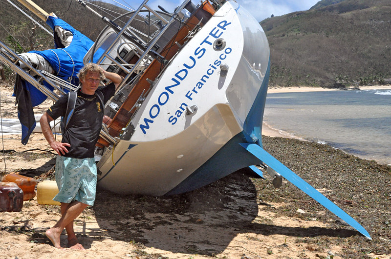
On our first visit to Moonduster, the boat looked so sound on the beach that I had a few moments’ thoughts of a possible salvage. But on going below, it was clear that the port side was stove in by the reef – the boat was full of sand and water. While the starboard-side interior looked clean and neat, the port-side furniture, including the galley and dining saloon looked as if a bomb had gone off – they’d been blown across the saloon making a dangerous mess of the entire interior.
So many of the local villagers were just incredibly friendly, warm and kind – one woman gave Neria a dress within moments of our arrival. And yet, others lied, looted and stole nearly everything we had – refusing to return even mementos that had value to no one but ourselves. We managed to extract my camera, the notebook computers and hard drives, some clothes and a few keepsakes. When we flew out of Nadi three days after the storm, the sum total of our possessions easily fell well within the Air New Zealand weight allowance.
Rethinking it all
Anchor systems
In the end, Moonduster hit the beach because two snubbers chafed through and then the anchor rode parted. The rode consisted of both a primary rode (250’ of 5/16 G4 chain) and a secondary rode (50’ of 5/16 G4 chain spliced to 300’ of 5/8 3-strand nylon) that were shackled together. The secondary rode was used a few times for a stern anchor but spent most of its life connected to the primary rode. The combination worked well when I anchored for a month in American Samoa’s Pagopago harbor in 80 feet of water and 25 knots of wind.
Neither of us heard the second snubber fail. In fact, we didn’t understand we lost the hook until the day after the storm when we examined the bow of the boat. Without the second snubber, there was nothing to relieve the load on the windlass. The constant strain had slowly back wound the motor and the chain had slowly been paid out. In the end, the boat was hanging on the 5/8” 3-strand nylon and that either chafed through or parted under load. Once free of the hook, we were doomed.
What’s clear now is that the rode should have been secured in such a way that the chain could not have left the hawse pipe. Had that been done, perhaps we’d have survived a few more hours. But I’m fairly sure that by Sunday afternoon, when the winds were strong from the west, that between the length of the rode and the position of the anchor in Likuliku bay, Moonduster would likely have been on the same beach albeit in a different location. The opportunity to relocate never occurred and Likuliku Bay is simply not survivable in 70 knot westerly winds.
Why didn’t you run?
For those who haven’t cruised in Fiji, its important to understand that the state of charts is quite different from those available in much of the rest of the South Pacific. Fijian waters include vast areas that are reef strewn and have never been surveyed. There is some detail on the charts derived from aerial photographs, but none of it is GPS corrected. As a result, the most obvious choice – to have run quick, fast and far to the west during the early phases of the storm’s development – was simply not an option. To the west of the Yasawa Islands is a north-south band of reef that is perhaps 50 nm wide. Crossing that band of reef in calm weather with the sun high in the sky is difficult. Crossing it in overcast conditions or at night with seas driven by 30, 40 and 50 knot winds would be suicidal. While it might be possible have saved the boat, it’s far more likely that we’d have hit a reef, lost the boat and wound up in the life raft – a risk we considered and rejected on Sunday morning and one we still believe was unacceptable.
Why not head into Vuda Point Marina or Musket Cove?
Each of these locations was about 35 nm from Likuliku Bay. Unfortunately, we had never been to either harbor and, as a result, had no track data or GPS information to guide us should we have decided to seek those harbors of refuge. We arrived at Likuliku at about 1330 on Sunday, at which time the wind was already about 30 knots from the east. Both of these locations were southeast of us and we’d have to sail 35 nm, hard on the wind, through reef strewn waters for which there are incomplete surveys on charts that aren’t GPS corrected. Presuming we could lay Musket Cove without tacking, my estimate is that it would take at least 7 hours and we’d arrive well after dark. And, because we couldn’t reach either harbor on the VHF, we had no idea whether they had room for us. So like the option discussed above, we concluded that these harbors were just too far away and the passage to them would be too dangerous. There was simply no way I was going to risk putting the boat on a reef at night leaving us in the life raft in open water.
Why were you in Fiji during Cyclone Season?
This is perhaps the most controversial of all the questions. Clearly had we left the tropics in November, like so much of the cruising fleet, there wouldn’t have been any issues with Cyclone Mick – we’d have been in Opua more than 1,000 nm to the south.
Our decision to be in Fiji during the first few weeks of The Season was largely based on the result of a massive refit during the months of June, July, August and September. That refit wrapped up on schedule and our plan was to do a short, 3-month cruise of Tonga and Fiji.
I had done quite a bit of research into cyclone season and the findings were pretty convincing. First, in the last 20 years there have only been three named storms that came within 200 miles of Nadi in December and none in November – of those three, only one formed before December 20th, our target date for leaving Fiji for New Zealand. Second, because December is so early in the season, those three storms all formed well to the north, where the water is warmer, and each took several days (5, 9 and 11) to reach Fijian waters giving lots of time to make plans for where to hole up or where to run. In all the 20 years of data I reviewed, there was nothing to suggest we might get surprised by a Tropical Cyclone in Fiji during the month of December with essentially no advance notice.
Beyond this analytic approach, I also spoke to a number of experienced cruisers, charter boat operators and officers of cruise and container ships that work throughout the Tonga/Fiji/Vanuatu/New Caledonia area. In every case, the collective wisdom was that some of the best cruising in both Fiji and Tonga was during the months of November and December – after the big “Puddle Jump” fleet had left and before the weather became treacherous.
Don’t you know the models used to generate GriBs don’t work well for Tropical Cyclones?
I did know this – it’s among the words of caution received along with the weather data when downloading GriBs via Sailmail. The issues is that these systems are so small and so intense that the models have a difficult time evaluating them given the scale at which they do their analysis.
My surprise is that the Nadi forecasts were also very inaccurate for this storm despite their usual high degree of accuracy with local weather. Throughout the storm, all the information that we received was in fairly close agreement with wind speeds and storm track and it was the lack of outlying data that suggested to us that the storm would be manageable.
That said, by Sunday afternoon, even if we’d received any data to suggest that the situation would be as bad as it became, it was simply too late for us to take action. The cards were drawn and we simply had to play our hand based upon the decisions we’d already made.
Why did you select Likuliku Bay?
Our choice to set up for the storm in Likuliku Bay was based on the best information we had. That information was that the storm would feature 40-knot winds and pass around midday on Sunday. The boat boys at the resort took their boats to Yalobi Bay at the southern end of Waya Island – where every boat sank during the strong southerlies during the day on Sunday. Similarly, the small cruise ship Reef Escape, sought refuge in Somosomo Bay at the southern end of Naviti Island just to the north of Waya. They, too, wound up on the beach during the strong southerlies on Sunday afternoon. The truth of the matter is that there is no all weather anchorage in the Yasawa Islands and the choice of Likuliku Bay combined with the plan to relocate to Nalauwaki Bay was entirely workable for a Category One storm with 40-knot winds moving past during daylight hours. There is simply no place in the Yasawa Islands that is survivable with 80-knot winds.
Conclusions
The details of Cyclone Mick and Likuliku Bay are an incredibly unfortunate chapter for Neria, myself and for the boat. But it’s done and over, two of us will move forward, one was left behind. Such is life.
I don’t believe in God, fate, or luck. I don’t give much credence to the saying, “That which doesn’t kill us serves to makes us stronger.” I do believe in science and statistics – I’m confident that the odds were in our favor and that we made the best decision based on the data available to us at the time. Clearly we were in the wrong place at the wrong time.
Perhaps it’s stubbornness, but after endless reevaluation of the situation, data available and choices made, I continue to believe that we made the best choices. Had we known Saturday evening that we’d be facing hurricane force winds, we may well have run early Sunday morning and made it west to open water or south east to Musket Cove.
What’s next?
I owned Moonduster for 18 years, the longest relationship of my adult life. We had good times, won races, cruised Mexico, Hawaii, Alaska, British Columbia, French Polynesia, Tonga, Samoa, New Zealand and Fiji traveling more than 30,000 nautical miles in the process. Through good times and bad times we took care of one another, drawing on strengths and overlooking faults. I had more fun with that boat than anyone deserves to have in two lifetimes.
Wooden boats have character; Moonduster had soul. I owe a debt of gratitude to the design team at Sparkman & Stephens who designed Moonduster, the staff at Crosshaven Boat Yard who built the beast so very well, and everyone at Svendsen’s Boat Works in Alameda who took fine care of Moonduster for so many years. Ben Souquet, Craig McInnes and Craig Partridge in New Zealand did simply amazing work during the recent refit in Opua. And to all those at Nalauwaki Bay who helped us to recover the few things we were able to salvage.
There will be other boats, but none will be like Moonduster. I have no regrets and I strongly encourage everyone who reads this to learn what they can and then get on with it. A life spent hiding from the weather is a life wasted. Get out and do it.
– Wayne Meretsky
New Zealand
December, 2009
Tropical Cyclones passing within 200nm of Nadi, Fiji since 1990
Past performance is no guarantee of future results
|
Year |
Name |
Cat* |
Days |
Storm |
Storm| |
|
1990 |
Sina |
5 |
5 |
Dec 24 |
Jan 04 |
|
1992 |
Joni |
4 |
9 |
Dec 05 |
Dec14 |
|
1992 |
Kina |
3 |
11 |
Dec 27 |
Jan 06 |
|
1993 |
Oli |
3 |
3 |
Feb 15 |
Feb 20 |
|
1997 |
Gavin |
4 |
6 |
Mar 02 |
Mar 14 |
|
1997 |
June |
1 |
9 |
May 02 |
May 11 |
|
2000 |
Iris |
1 |
5 |
Jan 06 |
Jan 10 |
|
2000 |
Neil |
1 |
1 |
Apr 13 |
Apr 20 |
|
2007 |
Gene |
1 |
3 |
Jan 26 |
Feb 6 |
Source www.australiasevereweather.com
* This is the strength of the storm as it traversed western Fijian waters
** Days between the dates the storm was classified a Tropical Cyclone and it entered western Fijian waters
This story is a continuation of a Sightings piece in the January 2010 issue of Latitude 38. To order a copy (complete with images in full color), use the subscription order form, and specify the 1/10 issue, or just drop us a note with a check for $7 to Latitude 38, Attn: Back Issues, 15 Locust Ave., Mill Valley, CA 94941.
Please note: After a couple of years, the actual issue may no longer be available, but we will still be able to make photocopies or PDFs of it.
You can also see issues on eBook through our eBooks page.
Comments